


 The following is the latest weather outlook issued by the Dominica Met Office at 6.00 am on Wednesday 24th August, 2016.
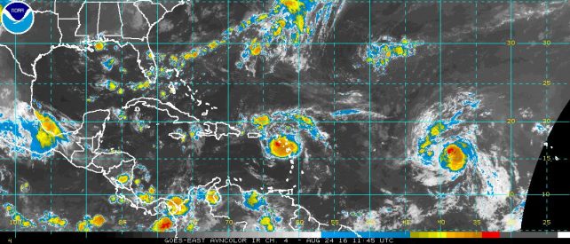
A strong tropical wave is affecting the northern portion of the region. This system is expected to result in an increase in cloudiness across the island during the next 24 hours. Showers activity and possible isolated thunderstorms can be expected by afternoon.
Persons in areas prone to flooding, landslides and falling rocks are advised to be vigilant and to continue to exercise caution.
Additionally, tropical storm Gaston continues on a west northwest track over the open waters of the central tropical Atlantic with maximum sustained winds now up to 70 mph. Further strengthening is forecast and the storm could become a hurricane later today.
Moderate sea conditions are expected during the next 24 hours with waves peaking near 7.0 feet.
It’s not that it’s a 100% failure , but Erika caught the people off guard n caused having n left most people petrified , and now they are no longer underestimating weather conditions… so any heavy rainfall or Storm, they take full caution…
Be constructive in yr criticism Dominicans don’t know what they wanted
The sun is hot in saint Lucia
I know the old saying better safe than sorry and also its just a forecast but prior to Erica we had 2 floods, no warning. Erica came along no warning. Post Erica we having severe weather alerts almost on a daily basis, flood warnings, landslides warning, rock fall warning and not a drop of rain occurring. That’s 100 per cent failure rate.
Should we ignore the met office and go to watherunderground instead. They have been much more accurate. We will surely get stuck again if the Met Office cant improve on their accuracy.