


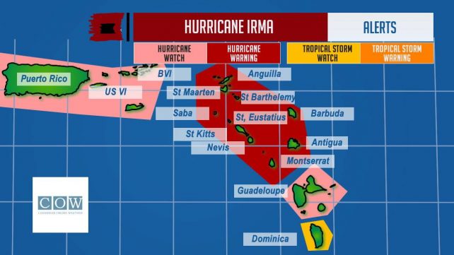
 A Tropical Storm Watch was issued for Dominica at 11:00 am on Monday.
A Tropical Storm Watch means that tropical storm conditions are possible within the watch area, in this case within 24-36 hours.
At 11:00 am, Hurricane Irma was located near latitude 16.8 degrees north and longitude 53.3 degrees west or about 560 miles east of the Leeward Islands and is moving west south west at 14mph. Maximum sustained winds remain near 120mph. The center of Hurricane Irma is projected to move over or just northeast of the northern Leeward Islands by Tuesday into Wednesday.
Outer bands associated with Hurricane Irma are expected to begin affecting Dominica by tonight.
Showers, which could be moderate to heavy at times, thunderstorms, gusty winds up to tropical storm force and dangerous seas are expected to affect Dominica up to Wednesday.
All users of the sea are advised to take all necessary precautions to protect life and property.
Expected rainfall amount for Dominica is between 3 to 4 inches (75 to 100mm) with higher amounts in elevated areas.
· Mariners and other users of the sea should remain extremely cautious and do not venture far from port.
· Persons in areas prone to flooding, landslides and falling rocks are advised to be extremely vigilant and to exercise extreme caution as flash flooding and winds gusting to tropical storm force are possible tonight into Wednesday.
The next Bulletin on Hurricane Irma will be issued by the Meteorological Service at 2:00 pm.

Stay safe all. Listen and watch