


 Hurricane Jose has been upgraded to a Category 4 storm.
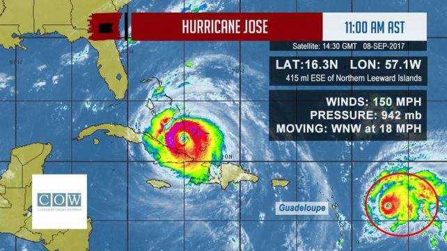
At 11:00 am, Jose was located near latitude 16.3 degrees north and longitude 57.1 degrees west or about 415 miles east south east of the Northern Leeward Islands.
Jose is moving towards the west north west near 18 mph with maximum sustained winds of 150 mph.
Interests in Dominica are advised to monitor the progress of Hurricane Jose and to make the necessary preparations as the system moves closer to the Leeward Islands.
The concern for Dominica at this time is possible impacts associated with feeder bands and rough seas due to Hurricane Jose. Current projection is for an increase in cloudiness, showers and thunderstorms, which could be moderate to heavy at times and gusty winds, by this afternoon and particularly on Saturday.
A flood watch or warning may be issued for Dominica later this afternoon.
Rough seas are expected during the next 24 hours with waves peaking near 14.0 feet. A small craft warning and a high surf advisory is now in effect for Dominica as of 12 noon.
All users of the sea and persons living near the coast are advised to take all the necessary precautions to protect life and property.
lord thank you for watching over us,you are so merciful and faithful to us,thank you we would not be able to withstand those hurricane father,thank you.