


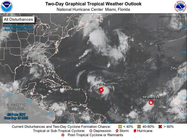
The tropical wave which was being monitored to the east of the Lesser Antilles became Tropical Depression #16 last night. At 5am, TD #16 was upgraded to Tropical Storm Peter near 18.0N 53.5W or about 630 miles east of the northern Leeward Islands. The centre of Peter is expected to pass well to the north of the northern Leeward Islands on Monday and Tuesday.
Moisture and instability associated with the tropical storm are expected to affect the northern half of the island chain, particularly the Leewards, during the next 24 to 48 hours. Cloudy spells with scattered showers are expected over Dominica with possible isolated thunderstorms during the period. The public is advised to remain vigilant.
Meanwhile, TD #17 also formed over the eastern Atlantic.
Moderate seas are anticipated during the next 24 hours, with waves peaking near 7.0ft today. An increase in swells up to 8.0ft are expected along the eastern coastline from tonight into Monday. Small craft operators and sea bathers on the east coast should be on alert and should exercise caution.
Disclaimer: The comments posted do not necessarily reflect the views of DominicaNewsOnline.com and its parent company or any individual staff member. All comments are posted subject to approval by DominicaNewsOnline.com. We never censor based on political or ideological points of view, but we do try to maintain a sensible balance between free speech and responsible moderating.
We will delete comments that:
See our full comment/user policy/agreement.