


A relatively dry atmosphere can be expected across the island today. However, light winds and daytime heating could trigger an increase in cloudiness with some light to moderate showers and possible isolated thunderstorms during the afternoon. People in areas prone to flooding, landslides and falling rocks should be on alert.
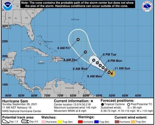
Still a major hurricane of category 4, the center of Hurricane Sam was located near 13.8°N, 49.7°W at 5am. Based on the projected path, intensity and forward speed, the system is expected to pass north of the Leeward Islands as a major hurricane by Wednesday. The public is advised to monitor the progress of this system.
Moderate seas are anticipated during the next 24 hours, with waves peaking to 7.0 feet. An increase in swells due to the approach of Hurricane Sam can be expected by late Monday. Small craft operators, sea bathers and people living near to or traversing coastal areas should be on alert.
Disclaimer: The comments posted do not necessarily reflect the views of DominicaNewsOnline.com and its parent company or any individual staff member. All comments are posted subject to approval by DominicaNewsOnline.com. We never censor based on political or ideological points of view, but we do try to maintain a sensible balance between free speech and responsible moderating.
We will delete comments that:
See our full comment/user policy/agreement.