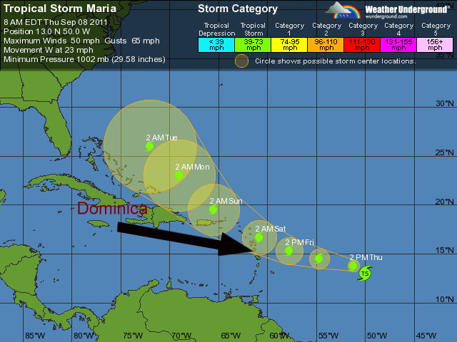
Tropical Storm Maria continues to speed across the Tropical Atlantic with little change in strength.
At 5 am the center of Tropical Storm Maria was located near latitude 13.5 north…longitude 48.2 west about 940 miles east southeast of the Leeward Islands.
Maria is moving toward the west near 23 mph and this general motion is expected to continue today, followed by a gradual turn toward the west-northwest and a decrease in forward speed on Friday.
On the forecast track the center of Maria is expected to approach the islands by Friday into Saturday. Maximum sustained winds are near 50 mph with higher gusts. Little change in strength is forecast during the next 48 hours. Tropical-storm-force winds extend outward up to 115 miles from the center. Tropical storm watches has been issued for The Leeward Islands; Antigua and Barbuda, Montserrat and Saint Kitts and Nevis.
Deterioration in weather conditions is expected by Friday as feeder bands from Maria are expected to begin spreading across the island. Sea swells will be a major concern and are expected to peak up to 4.0 metres by Friday into Saturday across the island.

THE GOVERNMENT OF BARBADOS HAS ISSUED A TROPICAL STORM WATCH FOR
DOMINICA.
THE GOVERNMENT OF CURACAO HAS ISSUED A TROPICAL STORM WATCH FOR
ST.MAARTIN…SABA…AND ST. EUSTATIUS.
SUMMARY OF WATCHES AND WARNINGS IN EFFECT…
A TROPICAL STORM WATCH IS IN EFFECT FOR…
* ANTIGUA…BARBUDA…MONTSERRAT…NEVIS…AND SAINT KITTS.
* ST BARTHELEMY…ST MARTEEN…GUADELOUPE…AND MARTINIQUE
* DOMINICA.
* ST.MAARTIN…SABA…AND ST. EUSTATIUS
A TROPICAL STORM WATCH MEANS THAT TROPICAL STORM CONDITIONS ARE
POSSIBLE WITHIN THE WATCH AREA…GENERALLY WITHIN 48 HOURS.
http://www.nhc.noaa.gov/text/refresh/MIATCPAT4+shtml/081443.shtml
Maria will pass north of us,will shave us so do not be complacent keep listening to advisories.Be vigilant always.
its more likely to pass south, with that projected path
God, please help us and protect us. Amen.
The hand of the Lord is not shortened that he cannot save,neither is his ear heavy that he cannot hear.(sami allahu leman hamida rabanna walackal hamnd).
How fitting that a simple-minded person posts such a simplistic thing. You’d think we were still sitting around fires and cooking the flesh of ancient mammals, praying that the stars would not fall on our head and that the rain would not stop our hunting tomorrow and that it would not be too cold to sleep, etc.
Wake up to the new millenium.