


A surface trough is expected to result in some cloudiness and scattered showers with a chance of isolated thunderstorms, across parts of the Lesser Antilles during the next 24 hours. An increase in activity is projected from later tonight and into Saturday. People in areas prone to flooding, landslides and falling rocks should exercise caution during the period.
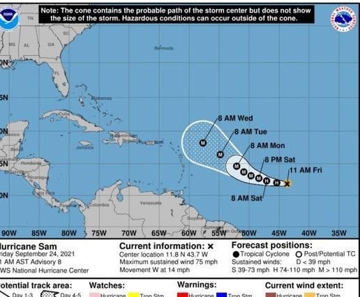
Sam is a Category 1 hurricane and is expected to continue to rapidly intensify. At 11am, Hurricane Sam was located near 11.8°N, 43.7°W. Based on the projected path, intensity and forward speed, the system is expected to pass north of the Leeward Islands as a major hurricane by next week. The public is advised to monitor the progress of this system.
Slight to moderate seas are anticipated during the next 24 hours, with waves peaking near 5.0 feet.
This hurricane needs to be carefully monitored.
Whilst its projected track takes it clear of Dominica, hurricanes are steered by pressure gradients and these can change – as has happened to our cost on previous occasions.
The “Discussion” page on the National Hurricane Center website is a valuable source of information.