


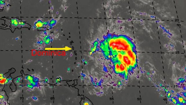
Shower and thunderstorm activity associated with a strong tropical wave and broad area of low pressure, located about 300 miles east of Barbados, continue to show signs of organization and a tropical cyclone could form tonight or Wednesday. The system is moving west to west-northwestward at 15 to 20 mph.
The general public is strongly advised to continue to monitor the progress of this system as watches or warnings could be required at any time.
The system is expected to bring moderate to heavy rains, scattered thunderstorms and strong gusty winds, possibly to tropical storm force across Dominica beginning tonight and continuing into Thursday. Current rainfall projection is between 3 to 6 inches (75 – 150mm) with higher amounts in elevated areas. Dangerous seas are also expected with waves peaking near 14 to 16 feet.
• Both coastal and inland flooding is possible.
• Mariners and other users of the sea are advised to be extremely cautious and to remain in port.
• Persons in areas prone to flooding, landslides and falling rocks are advised to be extremely vigilant and to exercise caution as life threatening flash flooding and strong winds are possible.
• Persons in vulnerable areas should plan ahead and take all precautionary measures to protect life and property particularly from tonight into Thursday. DO NOT ATTEMPT TO CROSS FLOODED ROAD or WATER-WAYS.
The Dominica Meteorological Service will continue to provide updates on the progress of this system.
Lord you have the power to calm the storm.
Protect my my nation lord amen.
Praying to god almighty that this storm rerouts it’s course and that my DA people will be safe. Love to all