


A high pressure system is expected to be dominant across the island resulting in occasional cloudiness and brief showers during today.
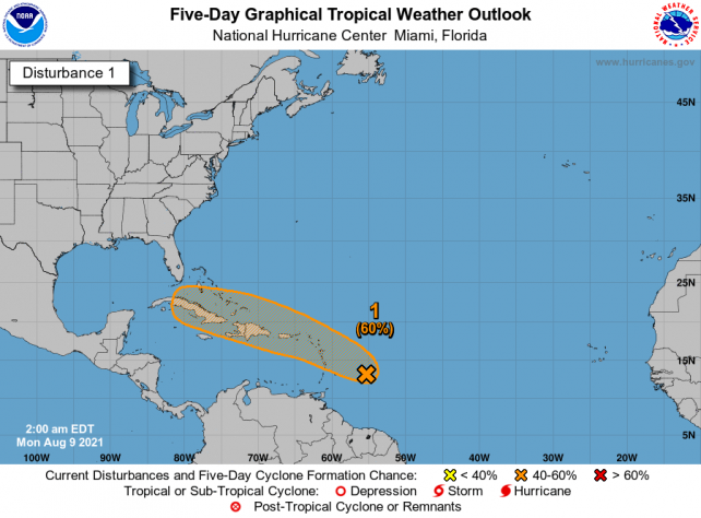
By this evening into tonight, an area of low pressure being monitored in the Atlantic for development will begin to affect the island. This system may become a depression on its approach to the islands. Moderate to heavy showers and thunderstorms are expected particularly across the northern half of the Lesser Antilles, including Dominica, into Tuesday. Projected rainfall is 4 to 6 inches during the period. A Flood Watch or Warning may be required.
People in areas prone to flooding, landslides and falling rocks are to remain on alert.
A second disturbance, in the central Atlantic with a low chance of development is also being monitored as it moves over the Atlantic. This system is expected to be near the Lesser Antilles by the weekend. Residents are advised to monitor the progress of these systems.
Moderate seas are anticipated during the next 24 hours with waves peaking near 8.0ft. A Small Craft Advisory is in effect for above normal seas on the east coast. Small craft operators and sea-bathers should exercise caution.
The Dominica Met. Service will continue to provide the necessary updates as they become available.
Please note that a greater degree of cloudiness, more frequent rainfall and higher rainfall amounts are normally experienced across the east coast and interior of Dominica.
Disclaimer: The comments posted do not necessarily reflect the views of DominicaNewsOnline.com and its parent company or any individual staff member. All comments are posted subject to approval by DominicaNewsOnline.com. We never censor based on political or ideological points of view, but we do try to maintain a sensible balance between free speech and responsible moderating.
We will delete comments that:
See our full comment/user policy/agreement.