


The 2024 Atlantic Hurricane Season officially comes to an end on November 30 after leaving a trail of destruction, death, and massive economic costs. Fortunately, Dominica was spared from major impacts but many countries in the Caribbean such as St Vincent, Grenada, Jamaica, and the Cayman Islands were not so lucky.
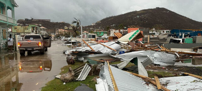
During the season, there were 18 named tropical storms. Eleven of those reached hurricane strength and five became major hurricanes – category three and above. The 2024 Hurricane Season started with a bang with Hurricane Beryl. Fueled by warm seas, it became the earliest Atlantic basin Category-5 hurricane on record. On July 1, it made landfall in the southern Caribbean, causing widespread devastation, particularly in St Vincent and the Grenadines and Grenada. Even Dominica felt some of its effects with heavy rainfall.
According to reports, in Saint Vincent and the Grenadines, 90 percent of infrastructure was damaged, including houses, roads, and the airport terminal on Union Island. In Grenada, Beryl made landfall in Carriacou as a Category 4 hurricane, damaging 95 percent of homes in Carriacou and Petite Martinique.
Beryl went on to cause devastation in Jamaica and the Cayman Islands, then moved towards the East coast of Mexico’s Yucatan Peninsula. It eventually made landfall in the United States on July 8. After Beryl, the Altantic Basin fell quiet, which was something of a surprise to climatologists. Typically the Hurricane Season reaches its peak in early September but after Beryl in July, there were only four named storms and no major hurricanes.
However, the season roared back to life with the formation of Hurricane Helene on September 24. Helene made landfall in the Big Bend area of the Florida Gulf Coast as a Category 4 storm late in the evening of September 26. Data from the US National Oceanic and Atmospheric Administration (NOAA) shows it was the deadliest hurricane to affect the continental US since Hurricane Katrina in 2005, causing more than 150 deaths.
Following Helene, six storms developed in quick succession with five becoming hurricanes. Of particular note is Hurricane Milton which formed in early October in the Gulf of Mexico and which saw its wind speeds increase by an eye-popping 90 miles per hour in 24 hours. Climatologists say it is one of the most extreme examples of rapid intensification on record.
The final storm of the 2024 Hurricane Season was Tropical Storm Sara. Although it never developed into a hurricane, it caused widespread flooding in Central America. The World Meteorological Organization (WMO), said 2024 was the ninth successive season with above-average activity in the Atlantic Basin. An average season produces 14 named storms, seven hurricanes, and three major hurricanes.
It warns that climate change is playing a big role in the formation, development, and intensity of storms.
“Year after year, the climate crisis continues to break new records, resulting in more extreme weather events, including rapidly intensifying tropical cyclones, intense rainfall, and flooding,” WMO Secretary-General Celeste Saulo said. “This July’s Hurricane Beryl, the earliest Category 5 hurricane on record, left a trail of destruction across the Caribbean. Despite its ferocity, the hurricane resulted in fewer deaths compared to previous ones. This was thanks to advances made by the countries of the region in strengthening their early warning systems.”
Although the Hurricane Season is officially over and many can breathe a sigh of relief, The Weather Channel has warned that it doesn’t mean no more storms can form. While 97 percent of Atlantic storm activities take place between June and November, what has been described as “outlier storms” can still cause major damage.
A typical example took place in 2013, when Dominica, along with St Lucia, was affected by a low-level trough system over a 24-hour period from Christmas Eve to Christmas Day.
The “freak storm,” as many people called it back then, dumped heavy rains on Dominica resulting in massive flooding and triggering landslides in several parts of the island. The stretch of road from Castle Comfort to Roseau was turned into a nightmare of mud, dirty water, snarled traffic, nervous pedestrians, and flooded homes on what was supposed to
be the biggest shopping day of the year. The Weather Channel said such storms take place when there is far too much wind shear, dry and cooler air, and cooler water to allow development after the Hurricane Season.
Disclaimer: The comments posted do not necessarily reflect the views of DominicaNewsOnline.com and its parent company or any individual staff member. All comments are posted subject to approval by DominicaNewsOnline.com. We never censor based on political or ideological points of view, but we do try to maintain a sensible balance between free speech and responsible moderating.
We will delete comments that:
See our full comment/user policy/agreement.