


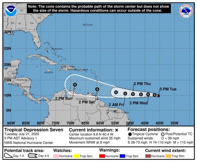
 Tropical Depression No. 7 formed at 5:00 pm this evening over the Central Tropical Atlantic near latitude 9.8 North, longitude 40.4 West or about 1420 miles East of the Southern Windward Islands. Strengthening is forecast during the next couple of days and the depression is expected to become a tropical storm tonight or Wednesday.
Shower and thunderstorm activity along with gusty winds ahead of TD No. 7 are projected to begin affecting the Lesser Antilles, including Dominica, from Thursday evening into Friday. The current projection is for the tropical cyclone to move across the southern Windward Islands to the south of Dominica throughout Saturday. Unstable conditions are therefore expected to linger across the island throughout most of the weekend.
Meanwhile, another active tropical wave is expected to generate shower and thunderstorm activity which could be heavy at times across Dominica, from Monday and throughout Tuesday of next week.
The public is advised to keep informed on these systems by listening to further updates provided by the Meteorological Service.
Moderate seas are expected during the next 24 hours with waves up to 7.0 feet. A further increase to peak near 8.0 feet is anticipated by Thursday.
A weak tropical wave is expected to produce cloudiness with brief scattered showers across the island chain during the next 12 to 24 hours.
Thanks DNO for the constant weather report. You are doing much better that the mainstream media. Keep up the good work.