


A tropical wave is expected to result in increased cloudiness, scattered showers and a slight chance of isolated thunderstorms mainly across the northern portion of the Lesser Antilles, including Dominica, during today.
People in areas prone to flooding, landslides and falling rocks should remain vigilant and are advised to exercise caution.
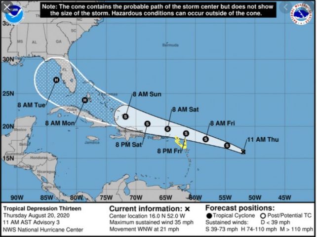
Meanwhile, Tropical Depression 13, which formed at 11 pm last night, continues its west-northwestward movement across the central Atlantic. On its present track, TD 13 is projected to pass just north of the Leeward Islands on Friday evening as a tropical storm. This system is expected to produce possible moderate to heavy shower and thunderstorm activity across Dominica from tomorrow Friday, particularly during the overnight period. Residents are advised to monitor the progress of this system as flood watches or warnings may be required.
Moderate seas are expected during the next 24 hours with waves peaking to 7.0ft. Small craft operators and sea bathers, particularly on the east coast, are advised to continue to exercise caution.
@D/can to d bone
Weather prediction is not an exact science. Sometimes the forecasts are spot on and at other times they can be off. It’s always better to prepare and nothing happens than to be completely unprepared and the prediction is accurate. Stop such an asinine comment.
Stop scaring people guys…the system is disorganise and besides it is taking a northwest turn..nothing ro worry about we safe..once its not dead west. So stop exagerating
who said anything about worrying?
Agreed!!!
I find those systems hardly passing close to us, come on! Yes they are unpredictable but it is obvious to even the lay person that there is no real cause for concern. At this point, there is no threat to us. When a system is going to be a real threat to us, we will know early enough, that, of course has been the case -even with Maria. We were hard hit, but we knew it was coming AT LEAST 12 hours before!
So all those urgent calls to “precautionary measures” every time we see something red or yellow in the Atlantic moving generally west, is not called for!
I hope I won’t be misunderstood.