


A relatively dry atmosphere can be expected during the earlier part of tonight. However, by after midnight and throughout tomorrow, Monday, an active tropical wave is expected to produce showers, which could be moderate to heavy at times, and thunderstorm activity across the island. People in areas prone to flooding, landslides and falling rocks should exercise caution during tomorrow.
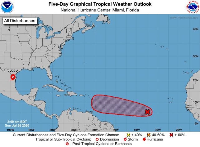
Meanwhile, another active tropical wave located in the Central Tropical Atlantic has a high chance of development and is projected to approach the area late Wednesday into Thursday. This wave is expected to become a tropical depression or tropical storm within the next two to three day.
Moderate seas are expected during the next 24 hours with wave height decreasing to 7.0ft. Small craft operators, all sea users and people living near the coast are advised to be vigilant as sea condition are expected to deteriorate as the week progresses.
The public is advised to continue making necessary preparations to secure life and property and to keep informed on these systems by listening to further updates provided by the Meteorological Service.
Disclaimer: The comments posted do not necessarily reflect the views of DominicaNewsOnline.com and its parent company or any individual staff member. All comments are posted subject to approval by DominicaNewsOnline.com. We never censor based on political or ideological points of view, but we do try to maintain a sensible balance between free speech and responsible moderating.
We will delete comments that:
See our full comment/user policy/agreement.