


An area of moisture ahead of Tropical Storm Tammy can be expected to result in an increase in cloudiness, scattered showers and possible thunderstorms across the island later today.
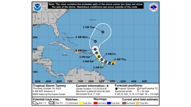
At 11am, Tropical Storm Tammy was located about 395 miles east southeast of Dominica and a Tropical Storm Watch remains in place. A Tropical Storm Watch means that tropical storm conditions are possible within the watch area within 48 hours. Tammy is moving west at about 15 mph with maximum sustained winds near 60mph with higher gusts. On this track, Tammy is expected to approach the area by Friday afternoon into Saturday.
This system has the potential to bring gusty winds, heavy rainfall and flooding to portions of the Lesser Antilles beginning Friday.
A deterioration in sea conditions can also be expected by Tonight and gradually become worse into the weekend and a small craft warning and a high surf advisory is now in place. Residents are advised to make all the necessary preparations to protect life and property and to stay tuned for updated information provided by the Met Office.
Disclaimer: The comments posted do not necessarily reflect the views of DominicaNewsOnline.com and its parent company or any individual staff member. All comments are posted subject to approval by DominicaNewsOnline.com. We never censor based on political or ideological points of view, but we do try to maintain a sensible balance between free speech and responsible moderating.
We will delete comments that:
See our full comment/user policy/agreement.