


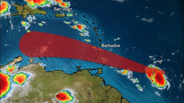
At 5 am, the centre of Gonzalo was located near latitude 10.0 North, longitude 51.8 West or about 645 miles east of the Southern Windward Islands. Gonzalo continues to move towards the west near 14mph (22 km/h) with maximum sustained winds near 60 mph (95 km/h) and the system could still become a hurricane during the next 24 hours before moving through the Southern Windward Islands. A westward to north-westward motion with an increase in forward speed is expected through the weekend. Gonzalo is a relatively small tropical cyclone with tropical-storm-force winds extending 25 miles from the center. There is significant uncertainty in forecasting Gonzalo’s intensity when it moves across the islands due to its small size and a Hurricane Hunter aircraft is scheduled to investigate the system this afternoon.
The current projection is for the tropical cyclone to move across the southern Windward Islands late Saturday into Sunday, about 200 miles to the south of Dominica, possibly as a hurricane. Shower and thunderstorm activity along with gusty winds associated with Gonzalo are projected to begin affecting the southern Windward from late Friday and Dominica on by Saturday afternoon into Sunday.
Unstable conditions are therefore expected to linger across the island throughout most of the weekend. Projected rainfall amount, during the period into Sunday, is 2 to 3 inches (50-75mm), with higher amounts in elevated areas. Flash flooding and landslides are therefore possible. A Flash Flood Watch or Warning may be issued as conditions warrant from Saturday evening.
Meanwhile, another active tropical wave is expected to generate shower and thunderstorm activity which could be heavy at times with gusty winds across Dominica, from Monday and throughout Tuesday of next week.
People in areas prone to flooding, landslides and falling rocks are advised to be vigilant and to exercise extreme caution during this projected wet spell from Saturday night and into early next week.
Gusty winds and a deterioration in sea conditions are anticipated in areas of showers and thunderstorms. Mariners and other users of the sea are therefore advised to exercise extreme caution during the period. A Small Craft Warning is now in effect for above normal seas.
The public is advised to keep informed on these systems by listening to further updates provided by the Dominica Meteorological Service.
Disclaimer: The comments posted do not necessarily reflect the views of DominicaNewsOnline.com and its parent company or any individual staff member. All comments are posted subject to approval by DominicaNewsOnline.com. We never censor based on political or ideological points of view, but we do try to maintain a sensible balance between free speech and responsible moderating.
We will delete comments that:
See our full comment/user policy/agreement.